DSpace CRIS
DSpace-CRIS consists of a data model describing objects of interest to Research and Development and a set of tools to manage the data. Standard DSpace is used to deal with publications and data sets, whereas DSpace-CRIS involves other CRIS entities: Researcher Pages, Projects, Organization Units and Second Level Dynamic Objects (single entities specialized by a profile, such as Journal, Prize, Event etc; because any profile can define its own set of properties and nested objects)
Learn MorePlease use this identifier to cite or link to this item:
https://hdl.handle.net/10316.2/43851| DC Field | Value | Language |
|---|---|---|
| dc.coverage.spatial | [c. 1:760 320] | |
| dc.date.accessioned | 2019-07-31T14:18:38Z | |
| dc.date.accessioned | 2020-03-18T16:43:08Z | - |
| dc.date.available | 2019-07-31T14:18:38Z | |
| dc.date.available | 2020-03-18T16:43:08Z | - |
| dc.date.issued | 1810 | |
| dc.identifier.uri | https://hdl.handle.net/10316.2/43851 | - |
| dc.description | Publicado juntamente com mais dois mapas em caixa denominada Spain. / published by W. Faden. | |
| dc.description | Margens graduadas. | |
| dc.description | Escala gráfica: Geographic or nautic miles, 60 to a degree ; 20 Spanish Leagues of 1572 Varas 17 1/2 to a degree ; 35 Castillan legal Leagues of 5000 Varas , 26 1/2 to a degree; 25 Portuguese Leagues, 19 to a degree ; 70 British Miles of 1760 yards, about 69 1/2 to a degree ; 20 Common French Leagues of 2282 Toises, 25 to a degree. | |
| dc.format.extent | 1 mapa em 4 f. em caixa : color. ; 58 x 81 cm cada folha | |
| dc.format.mimetype | application/pdf | |
| dc.format.mimetype | image/tiff | |
| dc.language.iso | eng | |
| dc.publisher | published by W. Faden geographer to His Majesty e to His Royal Highness the prince of Wales | |
| dc.rights | open access | - |
| dc.rights.uri | https://creativecommons.org/licenses/by/4.0 | - |
| dc.subject | Peninsula Ibérica | |
| dc.subject | Mapa | |
| dc.title | A new map of Spain and Portugal : exhibiting the chains of mountains with their passes, the principal & cross roads, with other details requisite for the intelligence of Military Operations | eng |
| dc.type | map | |
| uc.publication.location | Londres | |
| uc.publication.volume | Fl. 1 | |
| dc.contributor.publisher | Faden, William | |
| uc.publication.digCollection | BG | |
| uc.publication.digCollection | NC | |
| uc.publication.digLibrary | ucbg | |
| uc.publication.manifest | https://dl.uc.pt/json/iiif/10316.2/43851/155059/manifest?manifest=/json/iiif/10316.2/43851/155059/manifest | - |
| uc.publication.thumbnail | https://dl.uc.pt/retrieve/8562087 | - |
| uc.publication.copynote | Material frágil, acesso sob autorização. | |
| uc.publication.callnumber | NC-932, NC-933, NC-934, NC-935 | |
| uc.publication.siib | b2727479 | |
| uc.publication.images | 8 | |
| uc.publication.publisher | London : published by W. Faden geographer to His Majesty !e! to His Royal Highness the prince of Wales, Charing cross Jan. 1st 1810 | |
| dc.subject.udc | 912 (46) "18" | |
| uc.publication.subject | Peninsula Ibérica -- mapa -- 1810 | |
| dc.contributor.cartographer | Nantiat, Jasper | |
| uc.contributor.publisherView | Faden, William, 1749-1836 | |
| uc.publication.date | Charing cross Jan. 1st 1810 | |
| uc.contributor.cartographerView | Nantiat, Jasper | |
| uc.itemId | 55868 | - |
| uc.thumbnail.uri | https://dl.uc.pt/iiif-imgsrv/8560845/dl!4!UC!BG!-N!UCBG-NC-0932_0001_1_t0.tif | - |
| item.grantfulltext | open | - |
| item.fulltext | With Fulltext | - |
| Appears in Collections: | Teste - Nabais Conde reprocessados | |
Files in This Item:
| File | Description | Size | Format | |
|---|---|---|---|---|
| UCBG-NC-0932_0001_1_t0.tif | 193.03 MB | TIFF | 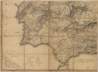 |
This item is licensed under a Creative Commons License
