DSpace CRIS
DSpace-CRIS consists of a data model describing objects of interest to Research and Development and a set of tools to manage the data. Standard DSpace is used to deal with publications and data sets, whereas DSpace-CRIS involves other CRIS entities: Researcher Pages, Projects, Organization Units and Second Level Dynamic Objects (single entities specialized by a profile, such as Journal, Prize, Event etc; because any profile can define its own set of properties and nested objects)
Learn MorePlease use this identifier to cite or link to this item:
https://hdl.handle.net/10316.2/43701| DC Field | Value | Language |
|---|---|---|
| dc.coverage.spatial | Escala não determinada | - |
| dc.date.accessioned | 2019-07-30T15:51:09Z | - |
| dc.date.available | 2019-07-30T15:51:09Z | - |
| dc.date.issued | 1762 | - |
| dc.identifier.uri | https://hdl.handle.net/10316.2/43701 | - |
| dc.description | Na margem inferior à esquerda apresenta cartela de titulo e cartela onde o autor dedica o mapa a John Earl of Bute : "To the Right Honourable John Earl of Bute, Viscount Kingarth, Baron Mountstuart, Cumbray and Inchmarnock; One of the Lords of His Majesty's most Honble. Privy Council, Knight of the most Antient e Most Noble Orders of the Thistle and Garter, and {u2026} "; as cartelas estão inseridas numa grande ilustração onde se destacam três figuras femininas representando Portugal e a Grâ-Bretanha. | - |
| dc.description | Margens graduadas. | - |
| dc.description | Apresenta notas explicativas da história e geografia do reino. | - |
| dc.description | Escala gráfica: 10 Legoas commuas de Portugal e d'Espanha 19. à hum Grao ; 40 Milhas Britannicas por Estatuto 69 1/2 à hum Grao ; 15 Legoas commuas de França 25 à hum Grao. | - |
| dc.format.extent | 1 mapa em 3 folhas : color ; folhas de 60x92 cm ou menor. | - |
| dc.format.mimetype | application/pdf | - |
| dc.format.mimetype | image/tiff | - |
| dc.language.iso | por | - |
| dc.publisher | [s.n.] | - |
| dc.rights | open access | - |
| dc.rights.uri | https://creativecommons.org/licenses/by/4.0 | - |
| dc.subject | Portugal | - |
| dc.title | Mappa ou carta geographica dos reinos de Portugal e Algarve | por |
| dc.type | map | - |
| uc.publication.location | Londres | - |
| uc.publication.volume | Fl. 1 | - |
| dc.contributor.printer | Rodrigues, Miguel | - |
| uc.publication.digCollection | BG | - |
| uc.publication.digCollection | NC | - |
| uc.publication.digLibrary | ucbg | - |
| uc.publication.manifest | https://dl.uc.pt/json/iiif/10316.2/43701/107272/manifest?manifest=/json/iiif/10316.2/43701/107272/manifest | - |
| uc.publication.thumbnail | https://dl.uc.pt/retrieve/5687823 | - |
| uc.publication.copynote | Material frágil, acesso sob autorização. | - |
| uc.publication.callnumber | NC-1224, NC-1225, NC-1226 | - |
| uc.publication.siib | b2722762 | - |
| uc.publication.images | 6 | |
| uc.publication.publisher | Londres : [s.n.], 1762 ([S.l.] : Miguel Rodrigues, impressor do Eminentissimo Senhor Cardial Patriarca) | - |
| dc.subject.udc | 912 (469) "17" | - |
| uc.publication.subject | Portugal -- mapa -- 1762 | - |
| dc.contributor.cartographer | Jefferys, Thomas | - |
| dc.contributor.cartographer | Ralph, B. | - |
| uc.contributor.printerView | Rodrigues, Miguel, 1689?-1775 | - |
| uc.publication.date | 1762 | - |
| uc.contributor.cartographerView | Jefferys, Thomas, c. 1710-1771 | - |
| uc.contributor.cartographerView | Ralph, B. | - |
| uc.itemId | 44964 | - |
| uc.thumbnail.uri | https://dl.uc.pt/iiif-imgsrv/5687669/dl!4!UC!BG!-N!UCBG-NC-1224_0001_1_t0.tif | - |
| item.grantfulltext | open | - |
| item.fulltext | With Fulltext | - |
| Appears in Collections: | Cartografia | |
Files in This Item:
| File | Description | Size | Format | |
|---|---|---|---|---|
| UCBG-NC-1224_0001_1_t0.tif | 228.38 MB | TIFF | 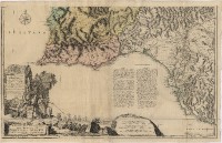 |
This item is licensed under a Creative Commons License
