DSpace CRIS
DSpace-CRIS consists of a data model describing objects of interest to Research and Development and a set of tools to manage the data. Standard DSpace is used to deal with publications and data sets, whereas DSpace-CRIS involves other CRIS entities: Researcher Pages, Projects, Organization Units and Second Level Dynamic Objects (single entities specialized by a profile, such as Journal, Prize, Event etc; because any profile can define its own set of properties and nested objects)
Learn MorePlease use this identifier to cite or link to this item:
https://hdl.handle.net/10316.2/43374| Title: | Pas Caert Vande Vlaemsche Eylanden | Keywords: | Açores;Mapa | Issue Date: | 1686 | Publisher: | Bij Iacob Colom op't Water | Description: | Cartela com o tít. rodeada de Neptuno, tritões e encimada por coluna. Escala gráfica: Duytsche mylen in een Graad; Spaensche mylen 17 1/2 in een Graad, Engelse en Franse mylen 20 in een Graad. |
URI: | https://hdl.handle.net/10316.2/43374 | Rights: | open access |
| Appears in Collections: | Cartografia |
Files in This Item:
| File | Description | Size | Format | |
|---|---|---|---|---|
| UCBG-NC-0646_0001_1_t0.tif | 132.83 MB | TIFF | 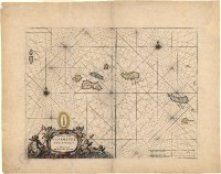 |
This item is licensed under a Creative Commons License
