DSpace CRIS
DSpace-CRIS consists of a data model describing objects of interest to Research and Development and a set of tools to manage the data. Standard DSpace is used to deal with publications and data sets, whereas DSpace-CRIS involves other CRIS entities: Researcher Pages, Projects, Organization Units and Second Level Dynamic Objects (single entities specialized by a profile, such as Journal, Prize, Event etc; because any profile can define its own set of properties and nested objects)
Learn MorePlease use this identifier to cite or link to this item:
https://hdl.handle.net/10316.2/43258| DC Field | Value | Language |
|---|---|---|
| dc.coverage.spatial | 1:20 260 | - |
| dc.date.accessioned | 2019-07-18T13:22:32Z | - |
| dc.date.available | 2019-07-18T13:22:32Z | - |
| dc.date.issued | 1930 | - |
| dc.identifier.uri | https://hdl.handle.net/10316.2/43258 | - |
| dc.format.extent | 1 mapa : p&b ; 97x65 cm | - |
| dc.format.mimetype | application/pdf | - |
| dc.format.mimetype | image/tiff | - |
| dc.language.iso | eng | - |
| dc.publisher | published at the Admiralty | - |
| dc.rights | open access | - |
| dc.rights.uri | https://creativecommons.org/licenses/by/4.0 | - |
| dc.subject | Argélia | - |
| dc.subject | Mar Mediterrâneo | - |
| dc.subject | Mapa | - |
| dc.title | Mediterranean : Algeric : approaches to Bone : from french government chart 1889 : with corrections from the french government chart 1929 | eng |
| dc.type | map | - |
| uc.publication.edition | New ed. | - |
| uc.publication.location | Londres | - |
| uc.publication.digCollection | BG | - |
| uc.publication.digCollection | NC | - |
| uc.publication.digLibrary | ucbg | - |
| uc.publication.manifest | https://dl.uc.pt/json/iiif/10316.2/43258/105896/manifest?manifest=/json/iiif/10316.2/43258/105896/manifest | - |
| uc.publication.manifest | https://dl.uc.pt/json/iiif/10316.2/43258/105896/manifest?manifest=/json/iiif/10316.2/43258/105896/manifest | - |
| uc.publication.thumbnail | https://dl.uc.pt/retrieve/5681173 | - |
| uc.publication.thumbnail | https://dl.uc.pt/retrieve/5681173 | - |
| uc.publication.copynote | Material frágil, acesso sob autorização. | - |
| uc.publication.callnumber | NC-460 | - |
| uc.publication.siib | b2702800 | - |
| uc.publication.images | 2 | |
| uc.publication.publisher | London : published at the Admiralty, 1930 | - |
| dc.subject.udc | 912 (65) "19" | - |
| dc.subject.udc | 912 (262) "19" | - |
| uc.publication.subject | Argélia -- mapa -- 1930 | - |
| uc.publication.subject | Mediterrâneo -- carta náutica -- 1930 | - |
| dc.contributor.cartographer | Wharton, W. J. L. | - |
| uc.publication.date | 1930 | - |
| uc.contributor.cartographerView | Wharton, W. J. L. | - |
| uc.itemId | 44516 | - |
| uc.thumbnail.uri | https://dl.uc.pt/iiif-imgsrv/5681006/dl!4!UC!BG!-N!UCBG-NC-0460_0001_1_t0.tif | - |
| item.fulltext | With Fulltext | - |
| item.grantfulltext | open | - |
| Appears in Collections: | Cartografia | |
Files in This Item:
| File | Description | Size | Format | |
|---|---|---|---|---|
| UCBG-NC-0460_0001_1_t0.tif | 298.06 MB | TIFF | 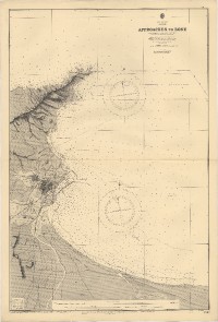 |
This item is licensed under a Creative Commons License
